Why is everyone going to the *south* pole of the Moon?
The lunar land down under
NASA’s Artemis program is only considering landing sites at the south pole of the Moon and not the north. China appears to be doing the same, and Jeff Bezos declared Blue Origin will mine water ice from Shackleton crater near the south pole. What gives?
This all suggests the lunar south pole is better in some respects than the north, like in solar energy or material resources or ease of landing. As I hope to show here this is not really the case. Differences between the poles are small and not meaningful on near to mid timescales. Instead, the south is favored for historical reasons with a key period between 1994–1999 that basically locked it in as the promised pole.
Midjourney
Stacking up the poles
Differences between the lunar poles are minimal. Each sit on highland terrain with mostly anorthositic composition, and feature a rugged landscape with large, degraded craters and smaller fresher ones.
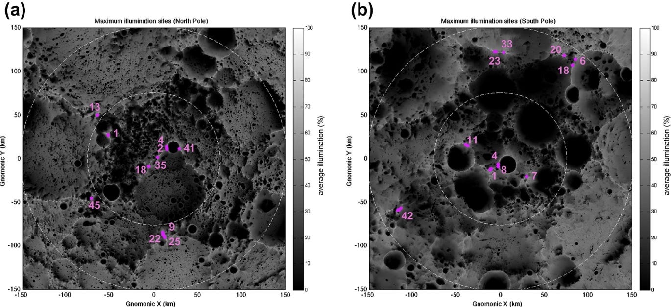
For solar energy, each pole has “peaks of eternal light” which are poorly named because we now know the light is not eternal: these locations are illuminated up to about 90% of the Moon’s 18.6-year nutation cycle. Seven of top twenty illuminated sites occur around the north pole based on the fraction of time one can see the sun at ground level. The range is fairly small: the #1 ranked site has solar visibility of 92.66%, and #20 has 87.65%. This would make no practical difference in how a base gets and stores its power.
Source: Mazarico et al. (2011)
So, in terms of solar energy the south pole gets a slight nod, but not one that has practical consequences: there are plenty of points with extremely good lighting at the north pole.
What about ice resources? This forms an important part of the story below, but the differences are smaller than they once seemed now that we have more complete data for each pole. Water ice has been inferred or detected at both poles from orbital neutron spectroscopy and reflectance spectroscopy from multiple instruments, with little to no difference in the nature of the detections. The south pole does have more area in permanent shadow, and more area with temperatures that are seasonally or permanently cold enough to trap ice on geologic timescales. But these differences are less than originally thought. For example, initial mapping by Nozette et al. in 1996 showed 6361 square kilometers of shadowed area around the south pole (within 2.5°) versus just 530 around the north. The true ratio of permanently shadowed area is now known to be about 1.25:1 south:north.
With estimates for the polar ice budget ranging up to 100 billion metric tons, any difference here will only matter once a good fraction of that ice is actually mined (say ~50%). Current plans I’ve seen are targeting 10s to maybe 100s of tons of water per year, or about 0.0000001% of the estimated total. If the ice is there (it’s buried if is), then there’s plenty of ice fields to be found in the north pole to last for decades at least.
The real tale
Instead of a fundamental discrepancy between the poles, the reason for the south being favored is historical. I’ve traced out the rough timeline below:
- 1834-1837: Wilhelm Beer and Johann Heinrich Mädler publish a series of lunar maps (Mappa Selenographica and Der Mond). These maps include the “Leibnitz Mountains” in the southern hemisphere, which it turns out are not actual mountains but an effect of the South Pole-Aitken (SPA) basin. But these “mountains” come back into play about 40 years later.
- 1880: Camille Flammarion publishes “Astronomie Populaire” and coins “les montagnes de l’éternelle lumière”. In English:
“The mountains Leibnitz and Dörfel lie near the south pole of our satellite. These two chains are sometimes seen in profile during eclipses of the sun; I observed and drew them during the eclipse of October 10, 1874. At the lunar poles (where, moreover, we see neither snow nor ice) there are mountains so strangely situated that their summits know no night; the sun never sets on them. They may be called the mountains of eternal light”
Midjourney
This planted seeds that would influence events below, but it wasn’t crucial: there were still plenty of opportunities left for each pole to shine.
- 1972-1990: John Westfall leads an effort within the lunar section of the Association of Lunar and Planetary Observers (ALPO) to fill in “luna incognita”, referring to a region around the south pole that was poorly mapped during missions in the 60s. The term luna incognita seems to have originated a few years earlier with Edward Phillips, referring to some poorly imaged far side regions in general (not the south pole specifically).
Now we jump to 1994 and reach the deciding five years.
---
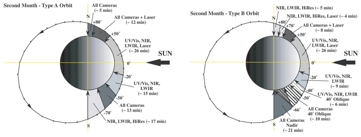
- January 25, 1994: The Clementine spacecraft launches, funded by the Ballistic Missile Defense Organization and NASA. It spends 71 days in orbit around the Moon, producing the first global digital imaging and topography products. Clementine’s orbit brought it closer to the south pole in the first month of mapping and to the north pole in the second month:
The two orbits are mirror images, but what may have ended up being the key difference here is the number of instruments (cameras, spectrometers, laser) that simultaneously imaged a greater slice of the south pole during each second month orbit (bottom right image). Which leads us to the first results published from Clementine.
- December 16, 1994: Gene Shoemaker and colleagues publish “The South Pole Region of the Moon as Seen by Clementine” in Science. This paper references luna incognita mentioned above and states the south pole was the least well-known region before the mission, hence its focus and intrigue. The decision to title this paper “The South Pole Region…” instead of “The Polar Regions…” is critical and was made even though Clementine had collected a good amount of data from the north. Because the Clementine mission occurred during lunar southern winter, the fraction of the south pole in shadow was at its maximum and the north pole its minimum, exaggerating this difference between them. The imaged shadowed regions are described in the paper as potential hosts of ice.
- 1998: This seems to be the first published mention of “peaks of eternal light” by Jeroen F. de Weerd et al. at the International Astronomical Congress in Melbourne, a slight rewording from Flammarion that has carried on to the present.
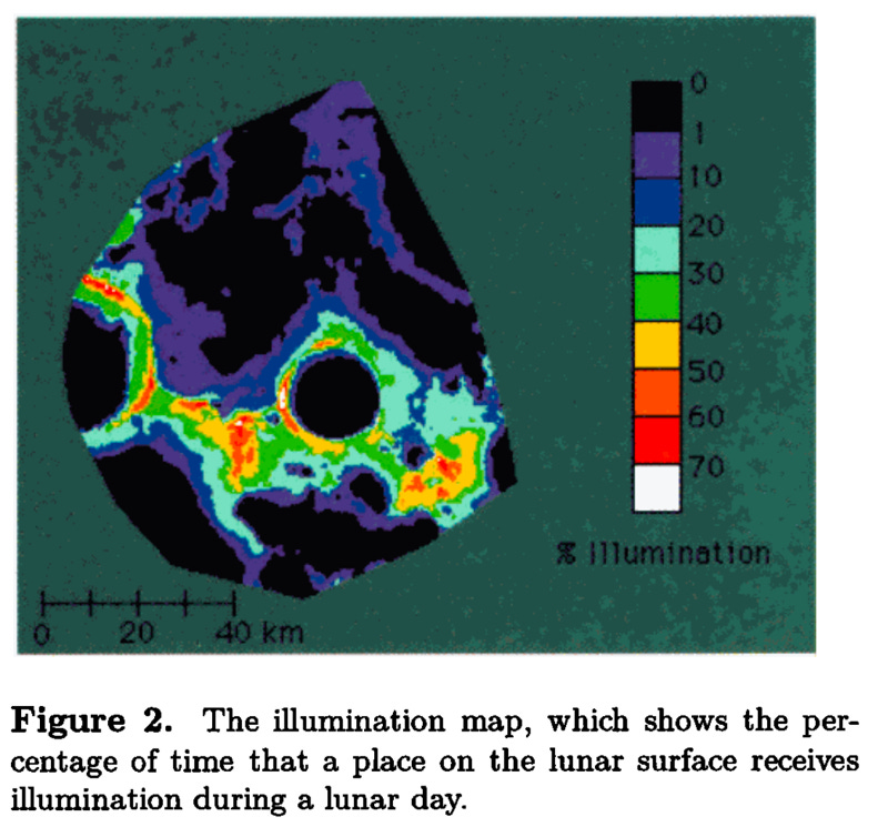
- May 1, 1999: Ben Bussey et al. publish “Illumination conditions at the lunar south pole” based on Clementine data. An additional motivating factor for focusing on the south is given:
“The location of the south pole, on the floor of the giant South Pole-Aitken basin, is of immense geological interest because of the possible presence of material from both the deep crust and upper mantle of the Moon either on, or close to, the surface.”
I think this paper is one of the last nails in the coffin for the north pole, particularly because it included this color plate of Shackleton and the ridge to its left:
To this day NASA and others remain laser-focused on Shackleton crater and the “Shackleton ridge”, probably in large part because that tiny slice of the pole is all that’s shown in the Bussey image. After this there was only one more chance for the north pole, but fate didn’t favor it.
---
- 2006 to 2009: When the Lunar Reconnaissance Orbiter (LRO) switches from a Delta Heavy to an Atlas V launch vehicle it frees up 1000 kg of launch mass. NASA solicits ideas for what to do with the extra room: enter the Lunar Crater Observation and Sensing Satellite (LCROSS) mission that will crash a rocket stage into a shadowed region to look for ice. There are community workshops held in 2006 and 2009 at NASA Ames to select a landing site for LCROSS. Originally, locations at both poles are considered, but the LRO launch date is delayed multiple times causing south pole sites to win out due to lighting and other factors. Cabeus crater is selected from the options considered.
If LRO wasn’t delayed and a north pole site was chosen instead, this could have put the poles back on roughly equal footing. As it played out, LCROSS crashed into Cabeus and cemented the large lead of the south pole from the Clementine days.
Midjourney
- May 4, 2015: LRO switches from a circular to a polar orbit with perilune near the south pole. This allows for much denser observations over the south than the north, particularly in terms of topography. The difference in data coverage makes it harder to carry out detailed site characterization for north polar sites compared to the south.
The takeaways
I believe four key factors came together in the period from 1994–1999 that caused the south pole to become heavily favored:
The south pole was described literally and figuratively as luna incognita: it was less well mapped and imaged and therefore was given higher priority to investigate with Clementine.
The Clementine mission took place in lunar southern winter which exaggerated the differences in shadowed areas between the poles.
The second month of Clementine had better coverage of the south pole with a synthesis of all its instruments, providing a more coherent story for publishing first results. The combo of 1–3 likely led Shoemaker et al. to title the 1994 paper as they did, and this set the stage going forward.
SPA also garnered strong interest, which probably influenced Ben Bussey and colleagues to publish Clementine lighting results for the south pole only. Their color image of illumination conditions around Shackleton had extremely long legs and became a powerful influence.
After this, only a northern LCROSS impact site could have reversed the course of events, but LRO launch delays ruled this out.
Since 1999, for the most part everyone has followed like lemmings in an unquestioned conviction the south pole is the destination of choice, eventually leading to recent outcomes from NASA, China, and Blue Origin described above.
I’m not arguing here the north pole is actually better (it isn’t), but instead that the very idea of one pole being “better” makes little sense, and along with it the blindfolded dash to the south. Which continent is better, South America or Australia? Not really a meaningful question without elaborating: they both have rivers, valleys, mountains, plenty of natural resources, etc. It would be nice to see people doing more of their own thinking on this one, but it seems we’re stuck in the southern rut for the time being.


